
 Tour 2011, stage 5: Kaltenbrunn/Fontanefredde - Martina (7 July 2011)
 |
159 km |
| 1620 m ^ | |
 |
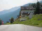
The road from Ora up to San Lugano 07-07-2011 08:27 11.3067°E, 46.3414°N, 500m |
 |
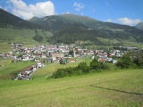
The plain and the lake of St Valentin 07-07-2011 15:24 10.5350°E, 46.7439°N, 1465m |
 |
Le church tower of Graun / Curon partly flooded by the lake of Reschen / Resia 07-07-2011 15:58 10.5375°E, 46.8097°N, 1500m |
 |
Nauders 07-07-2011 16:20 10.4925°E, 46.8925°N, 1385m |
 |
Norbertshöhe 07-07-2011 16:25 10.4850°E, 46.8950°N, 1406m |