
 MTB tour Bonaduz - Heinzenberg - Bischola - Safiental - Bonaduz (2 October 2010)
 |
57 km |
| 1869 m ^ | |
 |
Arrival at Luvreu 02-10-2010 10:59 9.4225°E, 46.7392°N, 740m |
 |
Short stop at the fountain of Luvreu 02-10-2010 11:00 9.4225°E, 46.7392°N, 740m |
 |
View from Tartar over the Domleschg and to the Albula valley 02-10-2010 11:36 9.4178°E, 46.7203°N, 980m |
 |
Sarn in Heinzenberg 02-10-2010 11:49 9.4164°E, 46.7161°N, 1030m |
 |
Flerden and the Piz Beverin 02-10-2010 11:51 9.4153°E, 46.7153°N, 1040m |
 |
Flerden's church 02-10-2010 12:15 9.4044°E, 46.7058°N, 1230m |
 |
Flerden's church 02-10-2010 12:22 9.4067°E, 46.7031°N, 1260m |
 |
Portein, Sarn, and Calanda in the background 02-10-2010 12:23 9.4067°E, 46.7031°N, 1260m |
 |
Fluppi, the photographed photographer, and the Piz Beverin 02-10-2010 12:51 9.3969°E, 46.7017°N, 1406m |
 |
Lunch stop: Guy, Denise, Shanti, René, Brombi, Ueli, Andri, Hannes, Lorenz, Fani, Adi 02-10-2010 12:51 9.3969°E, 46.7017°N, 1406m |
 |
Pause between Oberurmein et Rascheins, view towards: Fulhorn, Stätzerhorn, Piz Danis, Piz Scalottas and Lenzerhorn 02-10-2010 13:59 9.3758°E, 46.7042°N, 1730m |
 |
Glaspass in front of Piz Beverin and Bruschghorn 02-10-2010 14:31 9.3558°E, 46.6986°N, 1974m |
 |
Lüschalp, way to the Bischola Alp 02-10-2010 14:33 9.3558°E, 46.6986°N, 1974m |
 |
Lake Pascumin, with behind: Fulhorn, Stätzerhorn, Piz Danis 02-10-2010 14:44 9.3575°E, 46.7047°N, 1990m |
 |
Bischol lake and pass 02-10-2010 14:49 9.3581°E, 46.7061°N, 1990m |
 |
Bischol Lake, Piz Beverin and Bruschghorn 02-10-2010 14:51 9.3583°E, 46.7069°N, 1999m |
 |
Güner Lückli after the first snowfall (as seen from the Bischolpass) 02-10-2010 14:53 9.3583°E, 46.7069°N, 1999m |
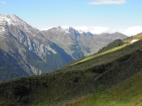 |
View from Bischolpass to the north-west (Safiental) 02-10-2010 14:56 9.3583°E, 46.7069°N, 1999m |
 |
Patrick at the Bischolpass 02-10-2010 14:58 9.3583°E, 46.7069°N, 1999m |
 |
Safiental, view from Mädelti to the north 02-10-2010 15:31 9.3397°E, 46.7111°N, 1600m |
 |
View from Mädelti over the Safiental to the Piz Fess 02-10-2010 15:32 9.3397°E, 46.7111°N, 1600m |
 |
Safien and the Piz Gün 02-10-2010 15:55 9.3306°E, 46.7058°N, 1270m |
 |
In the valley of Safiental, near Safien 02-10-2010 15:56 9.3306°E, 46.7058°N, 1270m |
 |
Rinmatta (Safien) 02-10-2010 16:11 9.3272°E, 46.7100°N, 1270m |
 |
Neukirch, view down along the Safiental, with Tenna on the left 02-10-2010 16:15 9.3294°E, 46.7153°N, 1290m |
 |
Egschi and its Reservoir 02-10-2010 16:19 9.3350°E, 46.7292°N, 1230m |
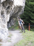 |
Fluppi in the Usser Salatobel 02-10-2010 16:53 9.3628°E, 46.7483°N, 1180m |
 |
Geisstobel 02-10-2010 16:57 9.3653°E, 46.7539°N, 1170m |
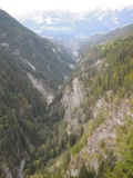 |
The lower Safiental as seen from Geisstobel, with Flims on the other side of the Rain Anteriur river 02-10-2010 16:57 9.3653°E, 46.7539°N, 1170m |
 |
Rain Anteriur river under Versam 02-10-2010 17:52 9.3428°E, 46.8061°N, 770m |