


Col de la Platrière
 |
FR (05), 6.7353°E, 44.8065°N | |||
 |
2220 m |  |
FR-05-2220a | |
 |
Guillestre, 1000m, 29km L'Estéyère, 1345m, 12km | |||
 |
Briançon, 1227m, 24km Izoard, 2361m, 3km Casse Déserte, 2196m, 1km | |||
 |


")
| Tour 2001 | ||
 |
intermediate pass on the south slope of the Izoard pass | |||
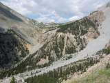
The Izoard pass as seen from the Plâtrière pass | ||||
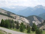
Near the Izoard pass, south slope, with the Pics de la Font Sancte in the background | ||||