


Otternpass
 |
CH (BE), 7.545°E, 46.5391°N | |||
 |
2278 m |  |
CH-BE-2278 | |
 |
Schwenden, 1174m, 12km Fildrich, 1361m, 8km Oberberg, 1929m, 2km | |||
 |
Achseten, 1060m, 8km Im Schwand, 1550m, 3km Otternalp, 1937m, 2km | |||
 |
||||
 |


")
| |||
 |
downhill only partly, and uphill almost not at all rideable track between Oberberg (Diemtigtal side) und Im Schwand (Engstlingental side) | |||
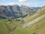
Oberberg,with the Rothorn in the background | ||||
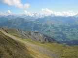
View from the Otternpass to the east with, at the horizon, Jungfrau (left, in the clouds), Oeschinenhorn (centre) and Doldenhorn (further right, in the clouds) | ||||
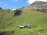
Otternalp and Otternpass | ||||