


Forcarella di Lago
 |
CH (TI), 9.0241°E, 46.3535°N | |||
 |
2256 m |  |
CH-TI-2256a | |
 |
Fontana, 1347m, 10km Ponte di Cengio, 1221m, 9km Alpe di Cava, 2005m, 1km | |||
 |
Biasca, 303m, 8km Canvasgia, 1290m, 5km Alpe di Compiett, 1516m, 3km | |||
 |
||||
 |


")
| |||
 |
long but good road over Val Pontirone up to the Alpe di Cava, pushing or carrying further up as well as on the west side (except in the middle part, which can be ridden) | |||
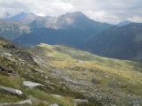
Alpe di Cava as seen from Forcarella di Lago, with the summits surrounding the Calanca valley at the horizon (Cima Rossa and Cima dei Cogn, Piz di Strega, Cima di Gagela) | ||||
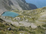
Alpe di Lago as seen from Forcarella di Lago | ||||